Have you built model using point cloud and met expectations?
sex việt,
9527 Westheimer Rd Houston Tx 77063,
England To Ireland,
Next Boxing Fight,
Hello Kitty Pi Ata,
Chicken Thigh Potato Tray Bake,
Mundial Qatar 2022,
Armstrongism,
Hbo Login,
Longines Classic Horse Race,
phim sex hay,
Man City Coat,
Ross Open Times,
Skillsjhare,
Stephanie Ruhle,
Where Was Converse Founded,
Lo Key,
Clay Bellinger,
Jp Morgan Stock Price,
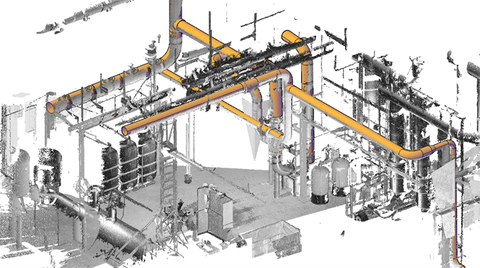
I came across this technology in 2010 at Ontario Revit User Group (ORUG) meeting in Toronto and believed this is an answer to all questions for existing site conditions. I did some test to import Point Cloud information in Revit and successfully linked few data sets. Point cloud in Revit was looking great and after some tweaking I could position in correctly. We could produce few crucial sections and elevations describing pinch points and justifying our design decisions and assumptions. It all worked out well as the intent was limited to understand site condition and create some guidelines for newly developed design.
Recently we got RFP for a SCAN to BIM project with a scope to develop a BIM model for verification of change in building structure. As this was a new scope for us, we started researching best practices with few industry experts. Realities I came across are worth sharing before you jump on a project and start build client’s expectations from a SCAN to BIM Project.
#1 – Point Cloud is accurate.
Technological developments in scanning industry has resulted great accuracy and precision in capturing data. As a SCAN to BIM provider we realized it’s not worth to achieve as accurate model as Point Cloud. Efforts to replicate existing construction into virtual world are complicated and time consuming. For example, in real world face of a wall may not be perfectly vertical and parallel to other wall. Modeling a non-vertical wall is time taking and not inline with Revit’s system wall family. This forces us to make assumption and model something practically achievable. Point Cloud is accurate but doesn’t work same way as Revit.
#2 – Develop consistency by making consistent assumptions.
Points are scattered all over and you need to establish your best guess to define a surface/face. As methodology we decided not to model minor variations and consider all wall suffices to match at particular level and establish cut plane height for best possible representation of wall surface. We developed all such assumptions and documents in our modelling strategy document.
#3 – Old School methods – still required.
If you think you need not to go back to the site you scanned. Sorry, the bad news is, you still need to go back and measure and verify. Other source of information is still required like any existing drawing, photographs and manual survey. Point cloud scan worked as guide and all additional information was used to make decisions for all modelled location and dimension.
#4 – Establish LOD 100 or 200
If you are planning to model for LOD 300 or beyond, make sure you understand the efforts and budget. There may be areas where LOD beyond 200 may be relevant and worth identifying in advance.
#5 – Available tools
In search of some possibility to ease modeling process we came across following tools. I am sure there are many more useful tools available.
Kubit VirtuSurv
Autodesk Revu
IMAGINiT’s Scan to BIM™
I realized a suitable modeling strategy and BIM Execution Plan is must to develop a quick and successful SCAN to BIM model. This model for existing site condition can be used as reference for variety of functions from design alteration to asset and facility management.
Image Source “www.leica-geosystems.com“


Leave A Comment